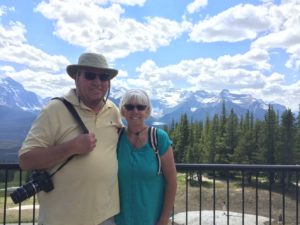
We got a later start out to Banff than what we thought we would. As we were looking at the things we wanted to do, we realized we couldn’t do them with Daisy. So we did a quick U-turn 20 minutes into the journey to return to the camper to leave her behind. But after finally getting on the road, we ran into a lot of traffic and we needed gas so we took a right turn and headed to a “road less travelled”. Instead of taking Canada Hwy 1, we took 1A instead through Cochrane. Found a Starbucks and headed out on our 1 hour 45 minute drive to Lake Louise. Traffic on this road was not bad and much more scenic as it wound around the Bow River and Ghost Lake. Our first stop was shuttle stop where we thought we were going to take a shuttle to Lake Louise to ride a Gondola. After parking, we talked with the Ranger who told us we were in the wrong place. So back to the car and another few miles down the road we made our way to the Lake Louise Ski Area. Here you could catch a shuttle into Lake Louise too and the lines were not as long. But, we were there to take the Gondola ride to the top of the mountain.
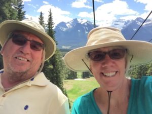
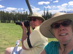
Lake Louise Gondola Ride
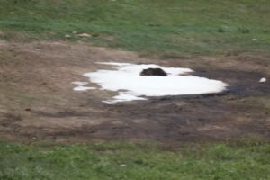
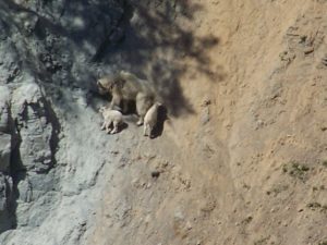
The black blob went from; I think it’s a Grizzly Bear to Grizzly Bear blob
Grizzly Bear blob
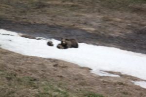
Grizzly Bear and 2 Cubs!!!!
Grizzly bear and 2 cubs
We saw a bear!!!!!! Our trip is complete and we didn’t even need any bear spray.
Gondola ride up, sporting the Tilley hat to keep me from getting sunburn on my headCamera ready for any future wildlife sightings.
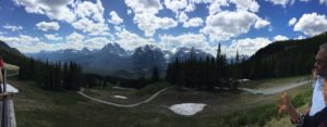
The views from the top were awesome!!
Pano view of the mountains
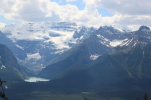
Lake Louise and Glacier
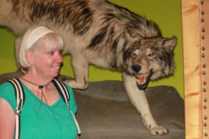
Visiting with wildlife at the interpretive center.
One of my favorite pics of the day…See Lake Louise over my shoulder
We decided we should head to Banff instead of taking the shuttle to Lake Louise. You have to remember that this was the Day after Canada Day and most people decided to come to Banff for the holiday weekend or week, who knows. It was crowded. We found another “road less traveled”.
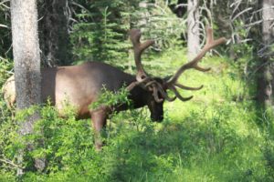
And although the speed limit was only about 35 mi/hr, but it was worth it as we drove up on a few cars pulled to the side and a woman outside of her car taking pictures. There on the side of the road was an Elk chomping on some leaves. Here is the best photo, we took many more!!
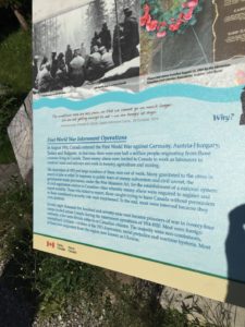
Also along this road, we came across a memorial for an Internment camps from the First World War across Canada. Neither of us even knew that Canada had them.
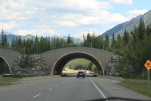
Wildlife corridor — allows wildlife to safely cross the highways.
While watching a film about how to live in bear country, we learned that many wildlife is killed trying to cross the roads. To prevent this from happening, in this park they have the roads lined with fences, but have these Wildlife corridors to allow wildlife to migrate and move the way they need to.
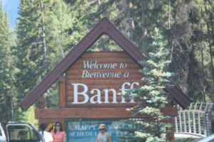
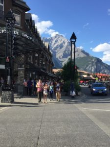
We finally make it Banff and boy are we starving!! So we found a parking spot – FREE PARKING!!
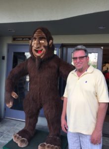
Curt and his brother “Bigfoot”
Banff reminded us of a modern Leavenworth, WA. It was so crowded; we had to walk far down the road to find a place to eat. But did find a wonderful Italian Restaurant where we had flatbread and salad.
Well again we wore ourselves out and had to drive back to the campground. Tomorrow we were going to be off to Edmonton Alberta, a short 3 hour drive north.
Our journey across the border went better than we thought.We were prepared with our passports, Daisy’s Rabies Documents, Registration for truck and camper, and PCS orders.We have read and heard (from the Alberta Visitor’s Center at Glacier National Forest) horror stories about crossing the border with a camper.We even threw out our fresh fruit and vegetables, and cheese and dairy (because the Visitor’s Center guide told us to) without needing to.The Border Guard asked us about firearms, asked where we were headed and for how long, and then came the dreaded question, “how much alcohol do you have?”Oh NO, we still have 5 cases of wine under the bed.We told the truth and then added that we were on military PCS orders on our way to Florida by way of the great country of Canada (OK, we didn’t say that “great country of Canada” part). And he passed us through just like that!
The drive to Calgary was really boring.It was like driving through the wheat fields of Kansas again.We ate our sandwiches sitting in the truck at a turn out’s because they don’t believe in rest areas.Thank God we had a camper so we could relieve ourselves.Curt says there were plenty of little towns to stop and get a “washroom” break, that is what they call it in Canada.
But what really drove Curt crazy was the low speed limits on the highway. Most of the way was 80-100 km / hr. Do you remember your teacher telling you that you had to learn metric because the US would be going to it soon…I’m still waiting. For those of you who didn’t memorize your metric system in grade school 70-100 km is 40-60 mi/hour, slow going for a highway.
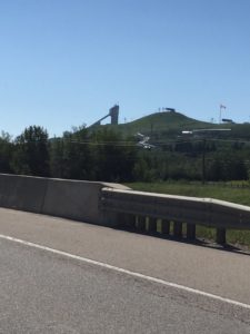
We got a tour of Calgary, thanks to the GPS who took us through the town during rush hour.Curt did great making the turns through the city because GPS thought it would be better to go on side streets instead of highways.The campground sits on a hill right next to WinSport.The training ground for the Olympic ski jumpers.In 1988 during the Winter Olympics this park was the primary venue for ski jumping, bobsleighing and luge.In the summer, they use the downhill trails for mountain biking.You put your bike on the chair lift up to the top of the mountain and then ride down the mountain.Curt and I tried this…NOT!
Winsport with high ski jump
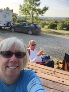
We don’t really like our RV spot as it is on a hill, so no place to set up the grill and the picnic table is at a 33 degree angle (per Curt) I think it is more like 45 degrees.But Daisy doesn’t mind as long as she can find a spot of sun to lay in, she is happy.Although the dogs here are not friendly; she got attacked by some pug looking dog our first morning walk.He went right for her throat.I think I was more upset than she was.We reported them to the front office, but we haven’t back there to find out if they were still there.And the dog next door also doesn’t like her.She has such a great disposition; she always thinks everyone is friendly.
Photo of the campsite—even see Daisy peaking around the chair.
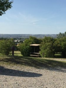
View from the campsite overlooking West Calgary. We watched the Canada Fireworks from our campsite and saw 3 shows at once.
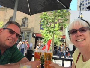
Our first day in Calgary, we drove downtown and discovered the town.First thing we did was visit the ATM to get some Canadian money.We talked with the Campground Store Clerk and asked for the best way to get downtown.He suggested the train, but we decided to drive instead.We did get a lesson on the Canadian “Loonie” or dollar.They don’t have dollar bills here, they instead use loonies and two dollar coins…oh and no pennies–round everything to the 5 cent.I think that I like that, pennies are useless anyway.
So Calgary is a city of about 1.1 million people and sits 3,440 feet elevation.It was established in 1875 as a North West Mounted Police fort.Also we noticed there were a lot of people of Asian origin and learned that back in the early 1900s the Chinese were recruited to build the railroads.We missed the Calgary Stampede by 5 days.It is a time when the locals relive the days of chuck wagons and lasso’s.
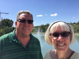
So we headed to Prince Island Park, a city park right in the middle of town.There were several performers, but mostly folks walking through on their lunch break.The parking situation reminded me of Seattle.The first place we pulled into park wanted $25 for 3 hours.We decided to find street parking that was $9 for 2 hours.We set our timer and off we went.
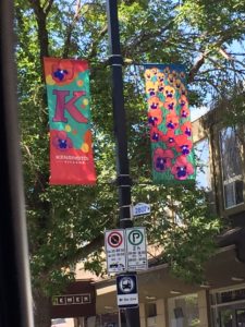
Kensington Village was a quaint neighborhood with stores, bars and restaurants.We had to stop here for obvious reasons.Mom, Dad and Aunt Mary all grew up in Kensington in Philly.It was just a little different from Philly.
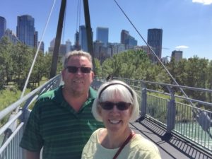
Selfie, and as Curt pointed out, I had to get the crane in the picture.We have noticed that most likely due to the long winters, summer is probably the only time they can get any construction done.There was construction everywhere, including road construction.
Finally remembered the Selfie Stick to take this picture of the Calgary skyline in the background.We were on one of the bridges over the Bow River, which runs through the town similar to Spokane River through Spokane.No big waterfalls, however.
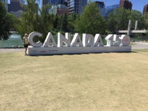
Canada is celebrating its sesquicentennial—Happy 150th Birthday!!
We walked up the road to Stephen Avenue Walk, where the street is blocked off and it is a walking mall, lined with shopping, outdoor cafés, and street vendors.There was a comic Con going on in town so it made for some interesting people watching while we ate lunch at an Irish Pub.
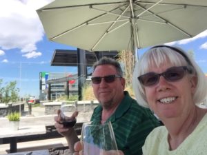
Like I said we only had 2 hours for all of this activity, so we had to hoof it back to the car before our time expired.We certainly did not want a Canadian parking ticket keeping us from gaining entry to the Country later on during our trip!We got back to the car and tried to find a parking spot closer to the Calgary Tower.We’ve been to the Seattle Tower, the San Antonio Tower, andthe Seoul Tower (South Korea) so we wanted to make a trek to the top of this one, but with street parking ending at 330 pm, lot parking was over $15 an hour, and the clock ticking at 220, we decided it wasn’t worth the stress or the money.Instead we headed home and found a cute wine bar…of course.
Unfortunately, there was only the view of the cars zooming down the highway, but we made the best of it–great conversation and time to plan our next day’s adventure.
The next day was Canada Day, July 1, Canada’s Independence Day.We decided to avoid the crowds and have a quiet day.It was great to sleep in and relax.What better day to do laundry!We drove to a local laundromat and spent a fortune to wash our 3 weeks of dirty clothes…don’t judge, it is not a task we enjoy.It rained for a few hours in the afternoon, but cleared up in time for the fireworks. As I said, our campsite gave us a great view of 3 different fireworks displays across the western part of the city.We got to bed right after that as a visit to Banff National Park was on the docket for tomorrow.
The day started off with a walk around the park for Daisy. There was a nice walking path that had lots of smells and sounds, she loved it. Unfortunately after the walk, she was banished to the air conditioned camper while we went to explore Glacier. Dogs are only allowed in the Visitor’s area, no hiking for her today.
What do you mean I can’t go on a hike??
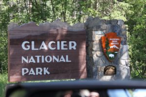
We Entered Glacier from the West side, walked around West Glacier Railroad Depot, stopped into the Alberta Canada visitor center and got some advice on what to do when we head to Calgary later in the week.
Fun Facts about Glacier National Park:
Glacier park is over a million acres in size with over 175 named mountains, 762 lakes, 563 streams, over 200 named waterfalls, 25 named glaciers, and over 745 miles of maintained hiking trails – Curt and I visited 3 trails and walked about 3 miles today! –Enjoyyourparks.com
“This park is one of the few places in North America where all the native carnivors (meat eating) survive. Grizzly and black bears forage amid the greenery along streams and avalanche slopes” says the Glacier Park Brochure—we haven’t seen any yet.
Over 250 kinds of birds and 70 species of mammals and 25 species of native fish live here.
Since we are early in the season, the “Going to the Sun Road” is not opened yet, they are still plowing the roads. It is hard to believe, because we didn’t see much snow, even at Avalanche Point, which was 14 miles up the mountain it was in the 80’s. We wore long pants and packed jackets in the car expecting cooler weather up there. The trail heads up at Avalanche were closed due to close encounters with bears. So we opted for a trailhead lower down the Mountain called Lake McDonald Loop.
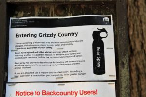
Speaking of bears, there was a sign as we entered the trail:
The Glacier Website recommends hikers to carry bear spray. We thought we should purchase it in town before we got to Glacier, surely they would mark it up here. So we stopped at Cabela’s and asked the salesperson what the difference between Pepper Spray and Bear Spray was. He said Bear Spray was stronger, so told us to purchase that. Well he was WRONG! After some research, this is what I learned. Pepper Spray and Bear Spray have the same active ingredient: oleoresin capsicum, the same chemical in chili peppers. But Pepper Spray is 10% stronger than the Bear Spray. The article said that we don’t want to “hurt or incapacite” the bear, but only want to scare him away….what???? Pepper spray, however, causes intense burning, difficulty breathing and lasts 20 minutes or longer, making it an effective self defense weapon to “subdue and incapacitate” the human threat…..what???? Oh and did we mention, pepper spray costs $10 and the bear spray costs $45. They are selling fear in a bottle. The only difference, besides the mark up, we could determine was the pepper spray only sprayed about 10 feet and the bear spray could reach 30 feet. We opted to purchase the bear spray and play it safe. So back to the story, today when we passed the sign that told us we were entering “Bear Country”, I asked Curt “where’s the bear spray?” “Back at the camper.” Great place for it, we ventured into the woods without our bear spray and as you can tell we made it back out alive.
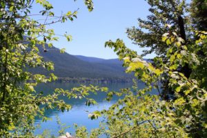
Below are some pictures we took of our sights, still did not see a glacier.
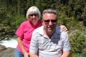
Lake McDonaldCurt sporting the retirement scruff?!?
Wild life viewed today: We had a close encounter with a deer, came within 8 feet of us while we were hiking. We also saw prairie dogs and chipmunks
Day 2
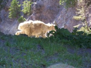
We drove around to the East Side of Glacier. The”Going to the Sun Road” was still not open and the Rangers could not predict when it will be open. We decided to take a boat trip around Two Medicines Lake. It was about an hour drive around the South end of the Park, following Rte 2 most of the way. Warren, our next door neighbor over the weekend and patent attorney, was full of great info since they ventured out there the day before. He told us exactly where to stop to see some billy goats and he did not disappoint. We stopped at “Goat Lick” Underpass, hint, hint there are goats here. We saw some goats, but there were clear across a big ravine, but I have a pretty good camera and was able to capture some shots of a Momma and her 3 kids (that is what baby goats are called). On the way home we stopped and saw a Daddy Goat up close and personal, probably within 20 feet, but there were loud people who scared the Goat before I got a good picture of him.
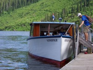
We arrived at the Medicine Lake Boat Tour window about 30 minutes before the 1300 (see I still tell time in military) and were put on a waiting list. We didn’t make the 1300, but I also put our names on the waiting list for the 1500, which we did make. The Boat Tour also included a 2 mile hike back to see Twin Falls. We got a little excited during this as people that were coming back towards us, kept telling us that they saw Moose down by the water. Aside: We spent 3 years in Washington and never saw a Moose, even though there were moose sightings all over Medical Lake and Airway Heights (2 small towns closest to the base)–so we were sure that we were not going to see a Moose. The closest we got was a hoof print in the mud and moose poop. I’ll spare you the picture of the poop, yes I did take a picture, but it came out a little blurry.
Our boat from the boat tour—Sinopah was the daughter of a Blackfeet Chief and one of the mountains was named for her.
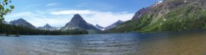
This is Sinopah mountain and this was our view from our picnic table as we ate our lunch.
View as we ate our picnic lunch
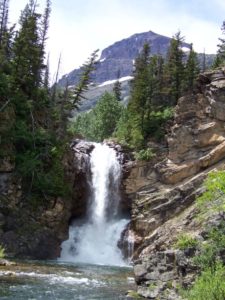
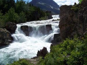
In addition to the Twin Falls, we saw lots of other water falls:
Running Eagle Falls
Running Eagle Falls
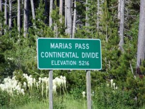
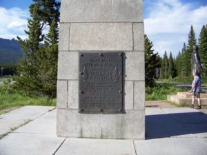
We stopped at the Continental Divide and found a monument to Theodore Roosevelt.
Continental DivideTeddy Roosevelt Monument at the Continental Divide.
So as far as hiking is going, Curt and I are doing pretty well getting in at least 10,000 steps. We are two for two. We plan on going to the other end of the Going to the Sun Road at Saint Mary’s and it will probably be a long day. We have to get an early start so we get back before dark (which by the way is at 2130).
Day 3
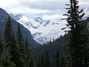
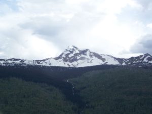
We did get up early and this time we took Daisy with us, because we knew it was going to be a long day. Even though we knew dogs could not go on the trails, we took her with us so that she would not be stuck in the camper all day. We were heading up to the East Glacier and the Saint Mary’s entrance. You could only go up 13 miles or so. This is the only time we saw a glacier. You would think that in Glacier National Park there would be lots of Glaciers, but you can only see one from the road. In the 1930s there were 150 Glaciers in Glacier National Park and now there are only 26 glaciers. There is a lot of snow on the mountains and it is hard to discern what is a Glacier and what is just “perennial” snow. A glacier by definition according to the ranger is at least 25 acres and “moving”. We saw one of the Glaciers, called Jackson Glacier:
Jackson Glacier, only glacier viewable from the Going to the Sun Road.
We had a picnic lunch with Daisy at one of the Turnouts:
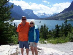
This is a picture of Wild Goose Island, where we saw no Geese:
Check out the Island over my shoulder, no geese to be seen!
Waterfalls are everywhere. We hiked to this one, not too far off the road, but it was scary as you had to go out on a rock to get this picture. I was watching and had to turn away while Curt took the picture.
Day 4
So today was supposed to be a “take it easy day” as tomorrow we knew we were leaving the park and driving to Calgary AB. But Curt decided we would drive to a winery, we passed on the way to this campground. But we started on the road and it was 1.5 hours back. Way too far to taste some overpriced wine. We don’t often leave a winery without buying a bottle of wine, but when you are on a retirement budget and the cheapest bottle of wine is $38, that is what we did. Instead, we doubled back to Walmart and bought some Black Box wine for $18.
As we are driving back into town, the signs tell us that the “Going to the Sun Road” is OPEN!!!!!! We leave tomorrow and tonight will be our only chance to see the road. It is 1730 (530 pm) and we decide to drop off the Walmart loot, pick up Daisy, make some Chicken Salad sandwiches (thanks to the Fritz’s for their Chicken) and headed out quickly. And boy was it worth it. Below are some pictures. As we said, we didn’t understand why the road was closed in the first place, because we didn’t see that much snow. But as we headed up to Logan’s pass, we saw the snow and the chance for avalanche from snow above as well. Pics below:
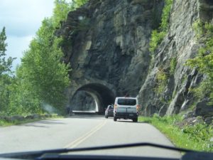
Heaven’s Peak at 8987 ftGoing to the Sun Road Tunnel
The road was curvy and the drive was scary, thin hairpin turns and with the extended mirrors, we thought for sure we would scrape the mountain!!!
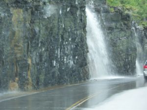
Weeping Wall was like driving through a water fall!
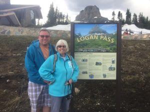
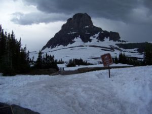
We made it to the top…Logan’s Pass:
Logan’s Pass — top of Going to the Sun Road
ON this picture, if you can zoom in, can you can see people walking up the mountain. It was a bit too cold for Curt and I so we headed back to the car, at our sandwiches and put the heat on. It was only about 45 degrees up there, but we were done!
It was well worth the ride and we flew down the mountain. It took us about 2 hours for the round trip, but glad we go to the opportunity to make it to the top. Glacier National Park Chapter complete!
Thanks to my brother, Charlie, who helped me set up this blog so that Curt and I could document our cross country trek and share our experiences with family and friends. The story starts when we left Fairchild AFB, one week after retirement. Our trip will take us to Florida, by way of Canada and everyplace in between.
So we packed up the trailer and headed out of Fairchild Air Force Base and headed East toward Glacier National Park.
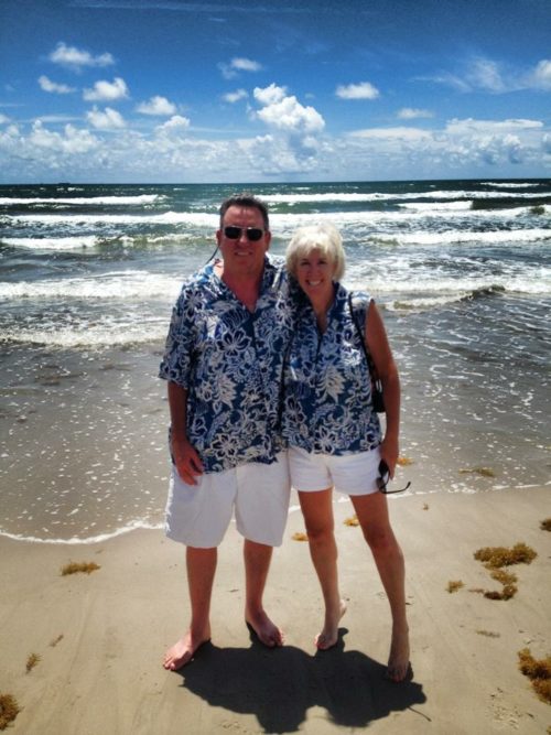
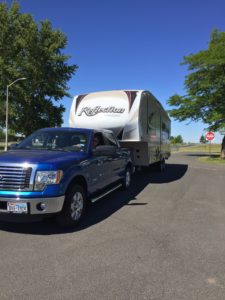
Our first trip in our new 5th Wheel we bought last summer.Good Bye 92d Medical Group
We started out across 90 and the WAZE app wanted to send us down to Mizzoula and then up I 93, but we decided to take a detour and head up North at Saint Regis at MT 135 (Exit 33) and followed the Clark Fork River. It was a beautiful drive and probably much better that over 90 to Mizzoula. But WAZE did have a brain fart, when it sent us down a road where they were doing construction and we had to wait about 20 minutes for a flag man to let us go and then followed a dude who went 15 mph for 15 miles, no lie. SOOOOOO SLOOOOOW.
So after this detour, we headed back to US 2 and headed into West Glacier MT. We decided to get our camping feet under us, since we have not gone “camping” in over a year and a half. We picked a KOA for our first camping trip. It was a bit expensive, but it was familiar to us. Curt made the reservation back in April for the trip and when I was reviewing our reservation on our way to the campground, I noticed it had us reserved for just 2 days: arriving Saturday and leaving on Monday. Ohhh Nooooo, we were supposed to stay until Thursday. We called the campground and told them we were supposed to stay longer and they found a way to make it work. We have beautiful site that is in the shadow of a big Mountain.
We met our neighbors, they went to Glacier yesterday and told us what to expect when we go there tomorrow. The KOA is pretty nice, we have an upgraded site that has a graveled patio and a grassy area for Daisy to lay out in the sun. We have an East facing site that keeps us in the shade in the afternoon. The place has a heated pool and an adult pool and spa. We hope to check it out while we are here.